
140000.0 आईएनआर/टुकड़ा
उत्पाद विवरण:
- वोल्टेज वोल्ट (v)
- पावर वाट (w)
- मटेरियल PLASTIC
- रंग BLOCK
- वर्गीकरण DETECTOR
- वज़न किलोग्राम (kg)
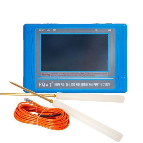
- प्रॉडक्ट टाइप PQWT - TC500
- अधिक देखने के लिए क्लिक करें
X
मूल्य और मात्रा
- 1
उत्पाद की विशेषताएं
- वाट (w)
- PLASTIC
- मिलीग्राम
- DIGITAL
- वोल्ट (v)
- PQWT - TC500
- किलोग्राम (kg)
- DETECTOR
- BLOCK
व्यापार सूचना
- प्रति महीने
- दिन
- Yes
Tell us about your requirement

Price: Â
Quantity
Select Unit
- 50
- 100
- 200
- 250
- 500
- 1000+
Additional detail
मोबाइल number
Email

जल डिटेक्टर अन्य उत्पाद


अमृता टेक्नोलॉजीज
GST : 36AJKPR8434L1ZH
GST : 36AJKPR8434L1ZH
सम्पर्क करने का विवरण
- बी नो. ा 69, ब्लॉक नो. 5, नियर राधिका थिएटर, पंचवटी एन्क्लेव, ेकिल पोस्ट,हैदराबाद - 500062, तेलंगाना, भारत
- फ़ोन : 08071792077


AMRUTHA TECHNOLOGIES
सर्वाधिकार सुरक्षित.(उपयोग की शर्तें)
इन्फोकॉम नेटवर्क प्राइवेट लिमिटेड . द्वारा विकसित एवं प्रबंधित
इन्फोकॉम नेटवर्क प्राइवेट लिमिटेड . द्वारा विकसित एवं प्रबंधित
